
53°34'30.1"N 9°37'17.9"E
The Schilling'sche Brack
Dyke construction, storm surges, Bracks (brackish water pools)
The medieval dykes protect the marshland from the daily flooding. However, they also reduced the flood areas. Therefore, the water rose higher and the dykes had to withstand this water pressure during storm surges.
Testimonies of the storm surge catastrophes are the brackish water pools (“Bracks”) elsewhere also called “Wehl” or officially “Kolk”. Brack describes the breaking of the dyke, “Wehl” the rooting of the water, “Kolk” the deep hole (Dutch kolk = abyss).
The extent and depth of the brackish water pools depend on the amount and fall height of the incoming water as well as the nature of the soil.
Where in earlier centuries the dykes were removed, the firm foundation was worse. Removing the dykes has taken place several times in the Altes Land. Thus, the location of the oldest Grünendeicher church lies nowadays outside the dyke in the Elbe before the Lühem estuary.
The dyke culverts required for drainage are also susceptible to dyke breaks. A collapse or an expulsion of the lock almost always results in a ground seepage. If the dyke is broken and cannot be closed immediately, water flows with every further tide into the Wettern behind it or a canal and an extensive and deep scour develops, such as the Great Brack in Borstel.
Bracks always lie on the inner side of a dyke break. They were later dyked, which explains some of the curves of the old dykes. The names of the Altländer Bracks refer to the place, the name of the “Kabelhalter” responsible for the dyke section, also called Kabel, or to natural features.
“No land without a dyke, no dyke without land” - the dyke method to this day is based on this statement. The Kabel dykes existed from the Middle Ages until 1962. Each piece of land was assigned a dyke section. The landowner was obliged to keep his Kabel dyke in a good condition. „Wer nich will dieken, mut wieken.” Whoever did not fulfil his dyke duty was expropriated. The spade was put into the Kable, the person who pulled it out, acquired the possession with all the associated dyke duties.
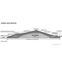
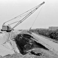
After the catastrophic floods in 1962 and 1976, the strategy of coastal protection has changed. The dyke system was cooperatively organised, the dyke line was straightened, the profile and construction were changed. Flatter angles of inclination reduce the waters’ destructive energy. The dykes’ core consists of sand and is covered with a compact layer of clay. Paths on both sides of the dyke facilitate its maintenance and defense in the event of storm surges. Ditches drain rainwater and seepage water as well as water from possible wave overflows.
For various reasons, a critical level has been reached today concerning the height of the dykes as the dead weight (ground pressure) increases alarmingly. The dykes had been raised further after the heavy storm surge in 1976 and are now 8 metres high. The subsoil is not all over sufficiently sustainable as the soil profile contains layers of varying stability. Further elevations cause the dyke to sink in some places. The intended slope angles cannot be achieved all over, since the necessary space is not available. Streets and houses restrict the possibilities. It is often not possible to move to the water side as the sustainability decreases regularly towards the Elbe.
The Schilling’sche Brack (brackish water pool)
The Brack emerged on 25 November 1685 from a dyke break during the infamous first Katharinenflut. The holder of the Kabel had to “stab the spade”, which meant expropriation.
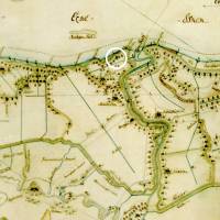
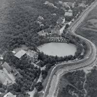
The Schilling’sche Brack lies on the Elbe dyke above the former Mojenhörn bay. In earlier centuries Mojenhörn was considered the most endangered dyke stretch of the first mile.
Around 1960 Hans-Peter Siemens wrote: “At the inn ‘Zur Elbschlucht’ the dyke at Kabel 59 now juts outwards with a mighty bastion; that’s the Brackhörne. The deep Brack lies in the dyke curve and is still 36 are [ 3.600 qm ] large. ... The Brack is connected to the south Wettern by a ditch and to the Elbe by a sluice.”
The Brack’s situation at the dyke of the Elbe has changed after the flood in 1962 due to its construction. The dyke was relocated and straightened on the side of the Elbe. Today the Brack is only 1.692 sqm large, it was partially backfilled. According to Jürgen Hoffmann, Cranz, it was still 10 m deep with a strong muddy ground in 2000.