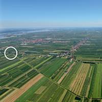
53°32'01.6"N 9°39'05.1"E
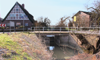
Lock of the Hinterdeich
The drainage system
Water actually needs a slope to drain. Draining the low-lying Sietland was a challenge. The colonists brought the knowledge about the drainage technology from their homeland Holland.
They dyked the land all around. The surface and inland water from the moors was held off by Hinterdeichen and drained by Wettern. The dyked land was lower than the sea level, but was now dyked all around and formed a polder. Before colonisation, every polder had to be drained. But even afterwards, the new marshland had to be continuously drained of rainwater and groundwater. Therefore, the inland water was always drained through the dykes to the outside.
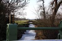
The drainage system in the Altes Land consists of the ditches and Wettern, the natural watercourses, as well as dyke gates through which the water shall drain. The system of natural watercourses - the canals - and artificial Wettern was already improved in the Middle Ages. A ditch was built between two plots of land, which led into a larger Wettern and which then took up the water from several ditches. The excavated soil was distributed to the lower cultivated areas so that they were artificially raised. It was necessary to drain the water from the lower Sietland through the highlands on the river banks. Therefore, the dyke gates and culverts had to be built as deep as possible into the dyke.
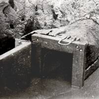
In the Altes Land, drains with flaps with only one gate are called sluices and drains with two gates are called locks. The technique used in the sluices has been developed from primitive drains via simple locks to larger so called "Torsielen" (approximately in 1500). During the colonisation of the Altes Land in the Middle Ages, water was channeled through ditches and primitive wooden sluices into rivers outside the dykes. At that time the sluices consisted of hollowed tree trunks, which provided a flap at the outer mouth. It was opened at low tide, when the inland water was higher than in the outer dyke, and closed at high tide so that no water could enter the polder from the outside. Dutch hydraulic engineers brought the principle of the locks made out of timber with two mitre lock gates from their homeland, which was a technical advance compared to the sluices.
The problem is that these dyke culverts are sensitive points in the dyke body due to their technical properties. If a lock or a sluice expels, it almost always results in a ground seepage in the dyke.
The colonists worked their way forward step by step. Starting at Stade at the Schwinge heading east. First up to the Lühe, then the 2 nd mile up to the Este river and at the end of the 12 th century the drainage systems were created with the 3 rd mile up to the South Elbe near Moorburg.
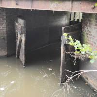
Neuenschleuser Wettern and lock at the Hinterdeich
The lock gates can be discovered in the shade under the bridge. Towards the south, the Neuenschleuser Wettern is crossed by many small bridges. Wettern and locks are examples of the water and drainage systems of the Altes Land and for the Hollerkolonisation which have grown historically and are still existential today. The Wettern absorbs water from the ditches from Neuenkirchen to the port of Neuenschleuse.
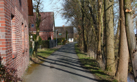
Over the bridge one arrives at the old historical Muddweg. The Muddweg is the border between Neuenkirchen (Southside of Muddweg) and MIttelnkirchen (Northside of Muddweg)
And to the north: The farms and houses left side belong to Mittelnkirchen.