53°32'23.4"N 9°41'33.6"E
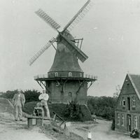
Old Elbe dyke with Mill "Aurora"
Dyke construction
Already before the Hollerkolonisation, there were settlements of Saxon origin on higher ground near the river. People lived on terps and on natural hills, such as sand dunes. – The St. Pankartius Church in Neuenfelde is located on such a dune. – The Sietland was crossed by tidal creeks and was exposed to tides (high and low tide).
The Archbishop of Bremen brought Dutch land developers to the Elbe in the early 12 th century to cultivate the Sietland. By the middle of the 13 th century, the colonisation was completed. During this time, the three miles were dyked and the drainage systems were established.
Each mile is a compartment surrounded by rivers and protected to the south by a Hinterdeich against the water from the moor belt. In some places, small quay dykes or Hinterdeiche still can be seen today. These parts have been dyked or removed during the colonisation.
The medieval dykes were lower than today and had steep slope angles. They entirely consisted of clay.
In 1935, even the highest dykes in the Altes Land did not reach the 5.33 metres level. However, they already had a much more beneficial slope ratio than in the 18 th century.
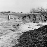
In the second half of the 20 th century, the Elbe dykes in the Altes Land were raised and their profiles were improved. After the disastrous storm surge in the Netherlands, people decided in a coastal plan in 1955 to raise the dykes to 6.60 metres NN embroidery height. In 1958, work was started in the first mile. If these measures had not been carried out at such an early stage, the dykes of the first mile would probably have been breached over a wide area during the storm surge disaster in February 1962. The water rose to 5.73 metres NN.
The predetermined height for the Elbe dyke in the area of the Altes Land was set at 7.20 metres NN and was raised to 8.00 metres NN in 1976 after the storm surge.
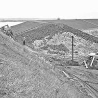
Today's Elbe dyke has a profile of 1:3 for the inner slope and at least 1:4 for the outer slope. Furthermore, the dyke is uniform in height, slope and width. The inner structure of today's Elbe dyke is also different. Today's technical possibilities allow to pump sand out of the Elbe and to pile it up (dyking) and which is then covered on the outside with a layer of clay.
The old dykes were not in uniform condition. Between the Middle Ages and 1963, the dyke management was organised according to the principle of Kabeldeichung. Each landowner was responsible for the dyke section assigned to his farm, the so-called Kabeldeichung. The condition of the dykes varied. In the middle of the 20 th century, it had become difficult to assign the respective responsible landowners and Deichkabel.
In 1963, the Kabeldeichung was converted into the cooperative form of the Kommunionsdeichung.
Since then, care and maintenance are commissioned by the dyke association and checked in joint dyke inspections by representatives of the lower dyke authority at the administrative district.
Dyke line
The construction of the first, older Lühe barrage in 1940 and the new construction in 1967 at the mouth of the Lühe (the rolling bridge was replaced by a bascule bridge in 1982), as well as the first Este barrage in 1958 and a new construction at the mouth of the Este in 2002, enabled to close these river mouths in the event of storm danger. The dykes of the tributaries "only" had to withstand the rising river water. Since then, the Elbe dykes and the barrages constitute the main dyke line during storm surges.
After the storm surge in 1962, the dyke line was re-designed. It was straightened and areas outside the dyke and the island of Hahnöfersand were dyked in 1976.
The dyke association of the second mile is responsible for a total dyke line of 12.1 kilometres of the Elbe dyke and 36.7 kilometres of protective dykes on the Este and Lühe rivers. The area of the association covers around 12,000 hectares and extends geographically to the contour line of 7 metres above sea level, i.e. to the Geest. In this area, the association comprises about 16,000 members and protects 50,000 people.
Old Elbe dyke with mill
The old Elbe dyke in Borstel is classified as a historical monument. This part of the historic dyke line was retained when the dyke line was straightened in the 1970s and the island of Hahnöfersand was also dyked. We can recognise the medieval dyke structure from the remains of the dyke. The dyke consists of clay. It has the typical steep slope angles. West of the dyke, we can guess the old dyke line. The main road follows the historic dyke line. The Port of Borstel and the orchards were outside the dyke until the 1970s.
History of the mill Aurora
There was no freedom of trade when the first windmill was established in Jork-Borstel. Without the privilege or permission of the landowner, no one was allowed to build and operate a new mill, even if they had the necessary financial means.
The Archbishop of Bremen granted the privilege to Gräfe Dietrich Schulte, who built the first post mill at the beginning of the 17 th century. In 1633, it is said that Gräfe Nicolas Dehmel rebuilt the completely ruined mill for his own benefit.
There was an accident in 1671, when a young man run his flour through the mill and came too close to the break wheel, which pulled him in and crushed him. As it was usual at that time, the mill then became state property.
One year later, the Swedish King announced that the mill could be redeemed for 100 Reichsthaler. Otto Wilhelm von Königsmarck was the son of the Governor General of the Duchies of Bremen/Verden, who was buried in Stade in 1663. He bought the mill and after his death his brother's descendants probably inherited the mill. The Countesses Aurora* and Amalia von Königsmarck are mentioned as lessors of the mill. It is assumed that Amalia Wilhelmine von Königsmarck owned the mill in Stade until her death in 1740.
George II of Hanover acquired the Agathenburg estates of the von Königsmarck family in the same year and thus also the Borstel mill. The Hanoverian Government wanted to get rid of the costly mill, however, they wanted to hold the regular income. Hence, the mill was advertised as an archbishopric mill for the highest bid.
After the storm surge in 1825, the dyke was raised by "four feet". Consequently, the windmill was no longer on the top of the dyke, but rather in the dyke. The young mill owner of that time, Adolf Friedrich Peters, had the post mill demolished and built today's Galerie-Holländer in 1856.
In 1943, the mill was damaged by bombs.
It was in operation until 1961, but could only grind with an engine.
At the end of the 1970s, the dyke line was moved forward to the island of Hahnöfersand and the Grünendeich-Cranz district road was rebuilt as main road.
The district of Stade wanted to acquire the mill, but had no budget funds. After consultation with the former head of the district, Dieter Diekmann, an agreement was reached with the mill owner. The district's committees took the necessary decisions. The reconstruction fund of Hamburg-Lower Saxony granted a significant sum as a subsidy.
After its restoration, a name was needed for the Borstel windmill. Since then, the Borstel windmill is called "Aurora" in memory of Aurora von Königsmarck.
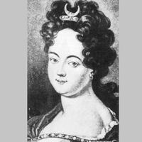
*(Maria Aurora Countess von Königsmarck - born on 28 April 1662 in Stade, died on 16 February 1728 in Quedlinburg - was descended from the Old Mark Brandenburg noble family of Königsmarck. She was mistress of King Augustus the Strong of Saxony and later Provost of Quedlinburg Abbey. Voltaire called her, besides Catherine the Great, "the most famous woman of two centuries").